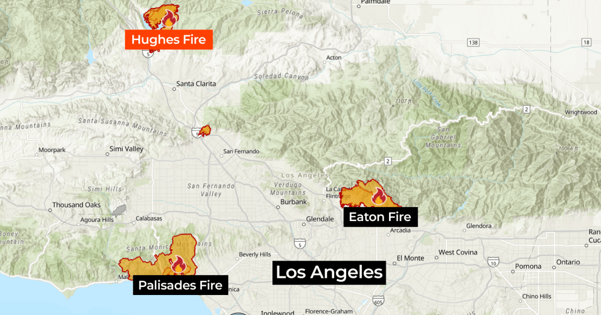
The new wildfire has burned more than 3,750 hectares near Castaic Lake, about 80 kilometers (50 miles) north of Los Angeles.
More than 50,000 residents have been warned to evacuate their homes after a wildfire raged in the mountains north of Los Angeles in the US state of California.
The Hughes Fire has burned about 3,750 hectares (9,266 acres) since it started on Wednesday and is completely out of control.
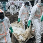
The latest blaze has added pressure on regional firefighters, who have battled two large wildfires in the Los Angeles metropolitan area, the Palisades and Eaton fires. According to LA County Fire Chief Anthony Marvin, more than 4,000 firefighters are now battling the Hughes fire.
Where is the Hughes wildfire burning?
The Hughes Fire is burning near Lake Hughes Road, near Castaic Lake, a large reservoir and popular recreation area north of Los Angeles.
The area is about 64 kilometers (40 miles) from the Eaton and Palisades fires, which have been burning for three weeks.
An estimated 18,600 people live in the local community where the raging flames have consumed trees and brush on the hillsides surrounding Caustic Lake.
What is the status of the Palisades and Eaton fires?
According to the California Department of Forestry and Fire Protection, there are at least three large active fires burning across the state. These include:
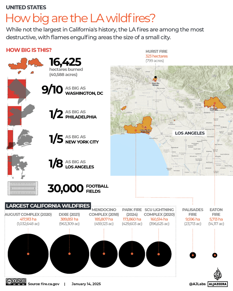
- The Palisades fire – 9,489 hectares (23,448 acres) burned, 70 percent contained.
- Eton Fire – 5,674 hectares (14,021 acres) burned, 95 percent contained.
- Hughes Fire – 3,750 hectares (9,266 acres) burned, 0 percent contained.
Four smaller fires, including Lilac, Clay, Sepulveda and Center, have also burned dozens of hectares across the state.
Containment means creating a barrier around a fire to stop it from spreading. However, this does not mean that the fire is completely contained or safe.
What’s driving these latest fires?
Like the Palisades and Eaton fires, high winds in the mountain valleys, combined with warm temperatures and low humidity, have fueled the Hughes fire.
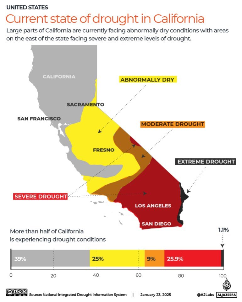
California often experiences exceptional drought conditions. Drought depletes trees, grasses and soil moisture making the landscape highly flammable.
Winter forest fires, once rare, are now more common. As the weather warms, the idea of specific wildfire seasons has shifted to the reality of year-round wildfires.
Large parts of California are currently experiencing unusually dry conditions, with areas in the eastern part of the state experiencing severe and extreme drought conditions.
Water reserves have reached extremely low levels, threatening both agriculture and the water supply for millions of residents.
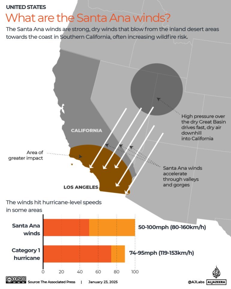
What are the Santa Ana winds?
Santa Ana winds are strong, dry winds that occur in Southern California, especially during the fall and winter months.
These winds blow from inland desert areas toward the coast and are driven by high pressure systems over the Great Basin, which is further inland, reaching surface hurricane speeds of 160km/h (100mph).
How big are the LA wildfires?
The LA fire has so far burned at least 16,425 hectares (40,587 acres). That’s about half the size of Washington, D.C., Philadelphia, one-eighth the size of Los Angeles, or about 30,000 football fields.
California typically experiences thousands of wildfires each year. These fires range from small brush fires to large, devastating fires that burn tens of thousands of hectares.